Moving on from Roma
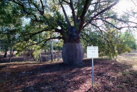
Before leaving town this morning, we had to visit the largest bottle tree in the town. These are quite weird looking trees with trunks that bulge out in the middle like a bottle, hence the name I suppose. (Depending on where you live, they’re also known as the Baobab, Boab or Upside-down Tree). After taking the necessary photo, we drove from Roma to Rubyvale, which is over 500 kms in a north west direction along the Carnarvon Highway.
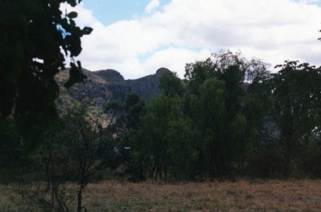
The road North covers some really beautiful countryside and as we go through the rocks and sandstone cliffs that border the Carnarvon National Park the views are quite spectacular. We stopped a couple of times to take photos of the cliffs and another huge Bottle tree.
We drove through Injune and they didn’t even notice we had been past, it was still very early and we didn’t see why we should disturb them or their breakfast. The guidebook said there was nothing to see anyway, even though they have tourist brochures telling us all about their nothing.
The next town on the way was a place called Rolleston; we stopped here on mild sentimental grounds as it had the same name as a town as I used to live near in Christchurch in New Zealand. We had a couple of stops to take photos near Rolleston. The day was warming up and we thought it might be time to stop and have a coffee. The local takeaway/coffee shop was a corrugated iron shed that was rather chic by design when you think we’re well into the Australian “Bush”. We ordered two cappuccinos, some nice cake and sat and waited, and waited. There was one guy serving, dishwashing, making sandwiches and making the coffee, oh and I forgot making conversation with whoever turned up. Oh well we are in the bush – can’t rush these people.
I read the newspaper while we waited and found the most exciting thing that had happened in the district was the capture of a couple of guys with a Hi Ace van full of Chop-Chop (Rough cut illegal tobacco), and the name of the policeman that caught them was Sergeant Ash!
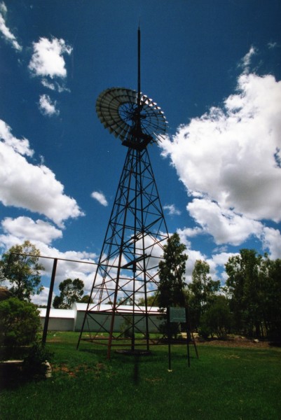
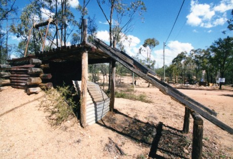
Eventually, we got out of Rolleston and headed northwest towards the Capricorn Highway which of course follows the Tropic of Capricorn from Rockhampton to Longreach. We stopped in on the way at the town of Springsure, they weren’t around to greet us either, but we visited anyway. On the way into the town there is a slab hut dating from around the 1860’s and a very large windmill. The Slab hut had a sign on it telling us it was open; but it was closed of course. We took the required photo and moved on.
Springsure sits in a valley with a number of small mountains surrounding it. The most spectacular is Mt Zamia and Virgin Rock. We took some time at finding some good vantage points to get some photos of Mt Zamia. We crossed the highway and climbed up banks etc to get a good vantage point. We couldn’t work out which rock was in fact Virgin Rock, or why it was so-named, and we also weren’t sure we really wanted to know. After we were all photographed out we drove off. About 2 Kilometres past the town there was a full photo vantage point, with maps, drawings and a potted history. We didn’t bother stopping – that was for the tourists; we had taken our art and were moving on. (Of course we may have found out why Virgin Rock was so named if we had stopped there).
With towns with names like Emerald, Sapphire and Rubyvale, it is not hard to guess you are in gemstone country. Sapphire is main stone that mined in the Sapphire and Rubyvale area. These little villages are a collection of ramshackle dwellings alongside piles of tailings. As you drive through the roads, the air is dusty; the whole place has a yellow dust over it, and everywhere are heaps of tailings, some abandoned, some in use. There are lots of narrow little streets; billboards advertise mine tours, gem cutting, and gem buying services. There is a drive-in bottle shop perched on a hillock in the middle of lots of tailings, it’s a very rudimentary bottle shop. It appears just like a tin hut covered in beer labels, only sandwich board displaying prices outside the door gives it away. This whole area appears so very basic. I think it may take more than a few sapphires for these people to make it big.
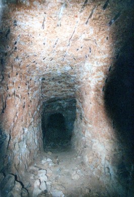
We thought it was about time to look for a place to put our tent up, so we pulled up at a caravan park in Rubyvale but there was nobody around. I went to the office and on the door was a sign saying “Closed today for Maintenance”. Who knows how many today’s that sign had been there for! Oh well we’ll find somewhere else, in the meantime we decided to do the main event that this little town offered, which was to go for a walk down a sapphire mine. We went to the “Miners Heritage” mine for our look down in the depths. The tour was great; they took us down over twenty metres into the tunnels. Mining has happened here for almost a hundred years. The sapphires are not obvious, buried in the fill of old riverbeds, you have to drill into the rock and hope to find something.
You can see the drill marks in the photo. They told us that they drop a shaft down in a straight line then mine to the west of it. The gems sit on the western side of the old riverbeds. The mine was self-ventilating, that is, a number of shafts reach down from ground level to crucial places. Temperature in the mine stays constant, between 22 and 25 degrees Celsius all year round, (great for the wine cellar) we appreciate the cool given that it was probably around 45C outside at the time. The main passages that we were walking around were lit very well. The tunnels were about six to seven feet high and about a metre wide. There was no wooden shoring in this mine. We’re shown many old shafts mined back at the beginning of the 20th century and into the 1930’s. These shafts were often dug by miners lying on their stomachs, with no more than a candlelight on their helmets. It must have been a terrifying experience in those days.
Today’s miners use modern equipment to dig the mine, move the rubble and screed the material afterwards. A very slick operation in today’s terms, but their rewards are not always guaranteed.
The mine tour over it was now time to find a place to stay for the night. We backtracked to Sapphire and went to a place that looked perfect. We drove up to the office of this very nice looking caravan park and camping grounds and went indoors. There was nobody around. I rang the bell and there was still no one around. I rang it again, we could hear a radio playing out back, someone must be here. I walked around the back and found the radio but no people. I went to the manager’s house next door which was fully open, and still there was nobody. We walked around the whole camp grounds; the only sign of life, someone snoozing outside their van, but that was about it.
It was like walking into the campground equivalent of the Marie Celeste. Walking around this campground, I felt like I do sometimes when we are playing a computer adventure game and you haven’t found something in the adventure that you should have. Nothing is going to alter in the scene until you find that something required to trigger the next scene. We spent over thirty minutes there and still no one appeared.
We gave up looking for whatever it was we were meant to find and moved on to the next little mining town. We finally found a place to put our tent up at a little town called Anakie. A first rate one star camp ground with all the grace and charm of a rubbish tip. The showers were cold, and they had the nerve to post a notice in the shower blocks asking us to limit the time in the shower to 3 minutes because of the water shortage! I think we both ran the taps for longer than that waiting for some hot water. The campsite appeared below the water line, but it did have the redeeming feature of being right next to the pub. Anyway just a place to lay the head until hitting the road the next day, just hope it doesn’t rain overnight.



Comments
Moving on from Roma — No Comments
HTML tags allowed in your comment: <a href="" title=""> <abbr title=""> <acronym title=""> <b> <blockquote cite=""> <cite> <code> <del datetime=""> <em> <i> <q cite=""> <s> <strike> <strong>